| Davis Rain Gauge Heater Disabled |
I have decided to shut off the heater in the Davis Rain Gauge since it is evaporating/sublimating all the snow recently. It has shown zero precipitation during recent snow events. The snow is very powdery and doesn't melt into the gauge. I'll reactivate it when needed. The heater consumes 33W and while not a lot of power, it doesn't help with the electric bill.
Expires Feb 6 at 8:41am EST |
Welcome to RogersCityWeather.com
Shortcut alias for this site is rcwx.tech

NovaLynx Gauge status: Winter Cover is ON - no precipitation will be recorded.

|
Updated: @
05-Feb-2026 10:51pm
|
| Summary / Temperature |
Wind |
Rain |
Outlook |

|
Mist, Overcast
|

|
25.3°F

Uncomfortably Cold
Feels like:
20°F
24-hr difference
36.9°F |
| |
Today |
Yesterday |
| High: |
27.1°F
4:52pm
|
25°F
3:23pm |
| Low: |
19°F
8:23am
|
9.3°F
6:07am |
|
|

|
SSW
5.8
Gust:
11.6 mph
|
|
2 Bft -
Light breeze
|
|
Today:
19 mph
10:23am
|
|
Gust Month: 23.3 mph
February 03
|
|
| Rain Today: |
0 in
|
| Rain Rate (/hr): |
0 in
|
| Rain Yesterday: |
0 in
|
| This Month: |
0 in
|
| Season Total: |
1.02 in
|
|
Friday

Chance Snow Showers And Patchy Blowing Snow
|
|
| Humidity & Barometer |
Almanac |
Moon |
| Humidity: |
92 %
|
| Dew Point: |
23.4°F
|
| Barometer: |
29.65 inHg
|
| Baro Trend: |
Falling Slowly
|
|
| Sunrise: |
7:50am |
| Sunset: |
5:47pm |
| Moonset: |
9:26am |
| Moonrise: |
10:27pm |
|
|
Waning Gibbous |

|
81%
Illuminated |
|
| UV Index |
Solar Radiation |
|
0.0
None
|
|
High: 1.3 @ 1:39pm
|
|
|
0 W/m2
(0 %)
|
|
High: 366 @
11:09am |
|
| NWS Weather Forecast - Outlook: Tonight & Friday |
Tonight

Chance Snow Showers
Lo 24 °F |
NWS forecast: A chance of snow showers and a slight chance of freezing drizzle. Cloudy, with a low around 24. Southwest wind 5 to 10 mph. Chance of precipitation is 50%. New snow accumulation of less than one inch possible.
|
| |
Friday
Chance Snow Showers And Patchy Blowing Snow
Hi 29 °F |
NWS forecast: A chance of snow showers before 10am, then a chance of snow showers and patchy blowing snow between 10am and 1pm, then patchy blowing snow and a slight chance of snow showers. Mostly cloudy. High near 29, with temperatures falling to around 15 in the afternoon. Wind chill values as low as -5. West wind 5 to 30 mph, with gusts as high as 45 mph. Chance of precipitation is 50%. New snow accumulation of around one inch possible. |
|
Quick jump to forecast for the week
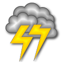 Current Great Lakes Lightning Map From Blitzortung
Michigan Lightning
Local Lightning
Current Great Lakes Lightning Map From Blitzortung
Michigan Lightning
Local Lightning
Smokey Says Today's Fire Danger is
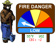
Note that since this station is close to Lake Huron, temperatures can be lower and humidities can be higher than further inland. Fire conditions can vary greatly even a few miles away.
Fire Danger Map
High Moisture Limitations:
With PM2.5 sensors, fog reflects the light, and can result in a higher reading. This is
characteristic to the inherent sensor design.
The condition occurs during rainy or foggy weather, where:
Outdoor Temperature - Dew point Temperature ≤ 2 ℃ 3.6 ℉
Ambient Weather PM25 Air Quality Monitor here at Station Location
Convert to AQI
We are hosting a lightning sensor for TOA Systems.